Having birded San Carlos Lake area a few times in recent years with other birding groups, I decided it was time to venture out that way on my own. My little Honda hybrid wouldn't do well on some of the sandy roads, so I was glad when Glenda Jones agreed to join me and take her bigger 4-wheel drive vehicle.
Although it would be a two-hour drive to reach our destination from Apache Junction, we stopped in Globe to pick up the required 24-HOUR RECREATION PERMIT @ $10/person to be carried with us (not left in the car). While the permit probably gives access to all of its 1.8 million acres, we would be visiting a very teeny piece of tribal land. We got our permits at the EXPRESS STOP gas station on the north side of Route 60 just prior to the final traffic light in Globe where Route 60 goes north to the White Mountains.
Continuing to head eastward at the traffic light, the highway became Route 70 which we took to Peridot, the first community along the way. At that point, we turned left onto Coolidge Dam Road (IR3) that circled down and beneath Route 70 to then take us south toward the lake and other places I wanted to check out.
First stop was the water treatment ponds. Well, access was easier last time I visited when we parked, opened the gate and walked in the dirt road. So, how were we going to bird the place now with it surrounded with chain-link fencing with double padlocks? We continued driving long the road to where the fence stopped and parked there at a sign for the Agricultural Center. Barbed wire is much easier to negotiate so we were able to walk past and bird through the chain link fence to the first two ponds.
With Doug Jenness on an AZFO survey a couple years ago, one team discovered additional ponds to the rear of the front two but, today, they were completely hidden from us with high berms around them in addition to being enclosed within the chain-link area. If there were ponds up there, we didn't see them,
A little after 7:30 a.m., Northern Shovelers were just beginning to swim out of the reeds in Pond 2 (2nd back from the highway). They were second highest in count after American Coots with two Lesser Scaup being the best among them all.
Desert birds were thick around the ponds with Black-throated Sparrows singing all over the place but I got visuals on only two of them. A Lincoln's Sparrow popped up to the top of a shrub just long enough for me to "get" it and the "pik" of the Ladder-backed Woodpecker added to our list.
We walked a dirt road between the sewage ponds and the agricultural fields on the east side of IR3. Canada Geese were just beginning to lift from the field.
 |
| Flying in two flocks of 22 each, we watched 44 Canada Geese lift off |
Then, slowly we drove south on IR3 with ag fields on the west. Very little traffic; very quiet. Lark Buntings were abundant and Glenda spied two male Brewer's Blackbirds. It was in this area that we saw the BIRD OF THE DAY!
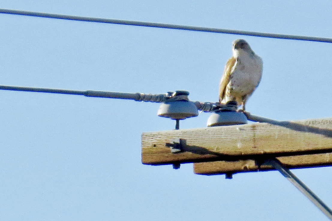
We did not close in on this perched FERRUGINOUS HAWK for fear of spooking it, so photos are distant and the best I could manage. I wasn't actually certain of the bird (I see this bird about once a year on group trips to Arlington Ag fields) so, when I got home, I sent a photo to raptor specialist, Claudia Kirscher, who confirmed this Ferruginous Hawk and gave me some good ID markers to always take into consideration.
 |
| Light morph Ferruginous Hawk |
The monument marks the location of the 'OLD SAN CARLOS" - that was submerged after Coolidge Dam was erected in 1928. Well, with no other signs to guide us, we had to make a choice when we arrived at a triple fork in the dirt road. The one to left looked less used; the other two well used, so we went forward...and forward. . .and forward... into amazing territory.

The road twisted and turned through various habitat including Joshua Trees (short and tall)
until the road narrowed and we found ourselves driving through very prickly tree limbs of reddish brown trees. They were scratching against the car. Since it was very birdy, we didn't turn back immediately but continued to find Loggerhead Shrikes, Black-throated and White Crowned Sparrows, Red-tailed Hawks, Verdin and Common Ravens. We even had a Great Blue Heron fly over us. Eventually, I suggested a turn-around since the road should have taken us to lake's edge by this time and we may have been running beside it. And, because I've been at this location when the lake is high and when it is low, I began thinking that even though we were on a rough road, it was really the river bottom. So, our ADVENTURE OF THE DAY, was River Bottom Road.
Glenda's GPS was of no use in there except for retracing our path - which is always helpful when I'm giving directions.
Next choice was to drive directly to the dam and backtrack to the monument location from there. We parked on the far side of the dam and birded down into the north waters of Pinal County.
 |
| San Carlos Lake from Coolidge Dam area (Pinal County) |
 |
| Cormorants appeared to be all Double-crested with juvies; gulls were all Ring-billed as far as we could scope |
Then, I heard a strange "WHO WHO WHO" but it didn't sound owl-like at all. I listened and listened but had no retrieval stuff going on in my head. It sounded like the Canyon Wren had stuck its head in a bucket - with the same descending rhythm but with a deep and resonating call.
When Glenda spotted the bird, I laughed. We see it much more than we hear it, but I should have known it was the "COO COO COO COOOOoooo" of this bird:
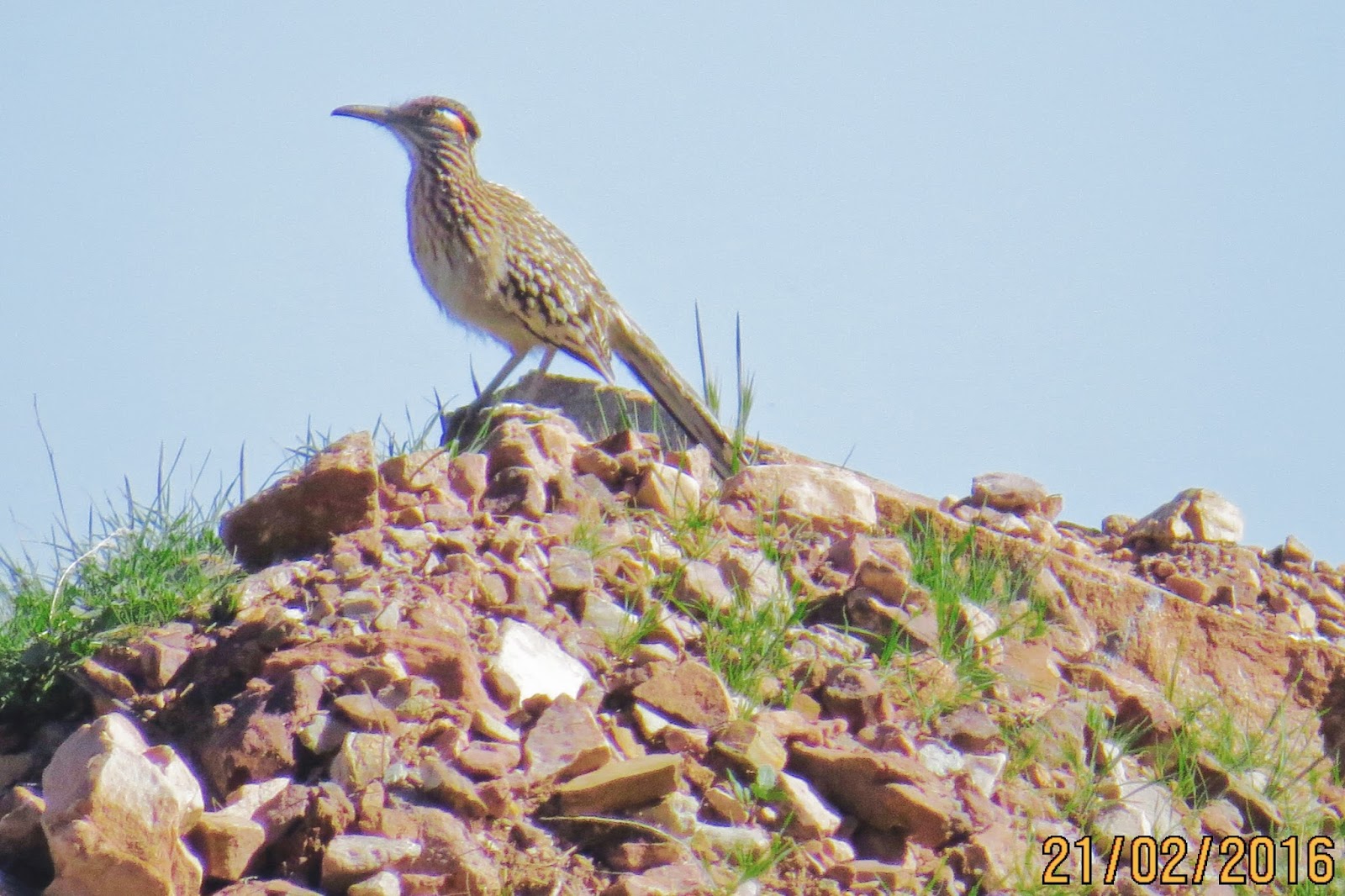 |
| Greater Roadrunner |
 |
| Route IR3 as it continues toward Calva and back to Route 70. We turned around rather than continue that direction. |
 |
| Sign at the Monument would have been helpful at the fork in the road! |


 |
| Glenda spotting the white pelicans, cormorants, etc. down on the lake. |
 |
| Get our your magnifying glass: these are some of the Am White Pelicans we saw in the distance there. |

Keep your magnifying glass handy. The two Brewer's Sparrows (one on the left; one on the right) were FOY (first of season or first of year birds for me) so I was glad to be able to catch a photo of them.
It was a day full of action and adventure; it was quiet with but one boat on the lake (a small quiet fishing one); few people and lots of wide open space. I think there's a re-run coming up during migration.
* * *
View this checklist online at http://ebird.org/ebird/view/checklist?subID=S27754600
View this checklist online at http://ebird.org/ebird/view/checklist?subID=S27754815
View this checklist online at http://ebird.org/ebird/view/checklist?subID=S27755110
View this checklist online at http://ebird.org/ebird/view/checklist?subID=S27755432
No comments:
Post a Comment